egeniouss Localisation
within Naviki
Better Positioning,
Less Satellite Dependence
Experience Visual Localisation within Naviki
Even more accurate positioning in urban areas
The new egeniouss technology provides more accurate and reliable positioning where satellite based localisation has its limitations – in urban canyons and near large buildings. Naviki is one the the first apps wordwide, making use of egeniouss. Experience even more precise bicycle navigation and recorded trips with Naviki and egeniouss.
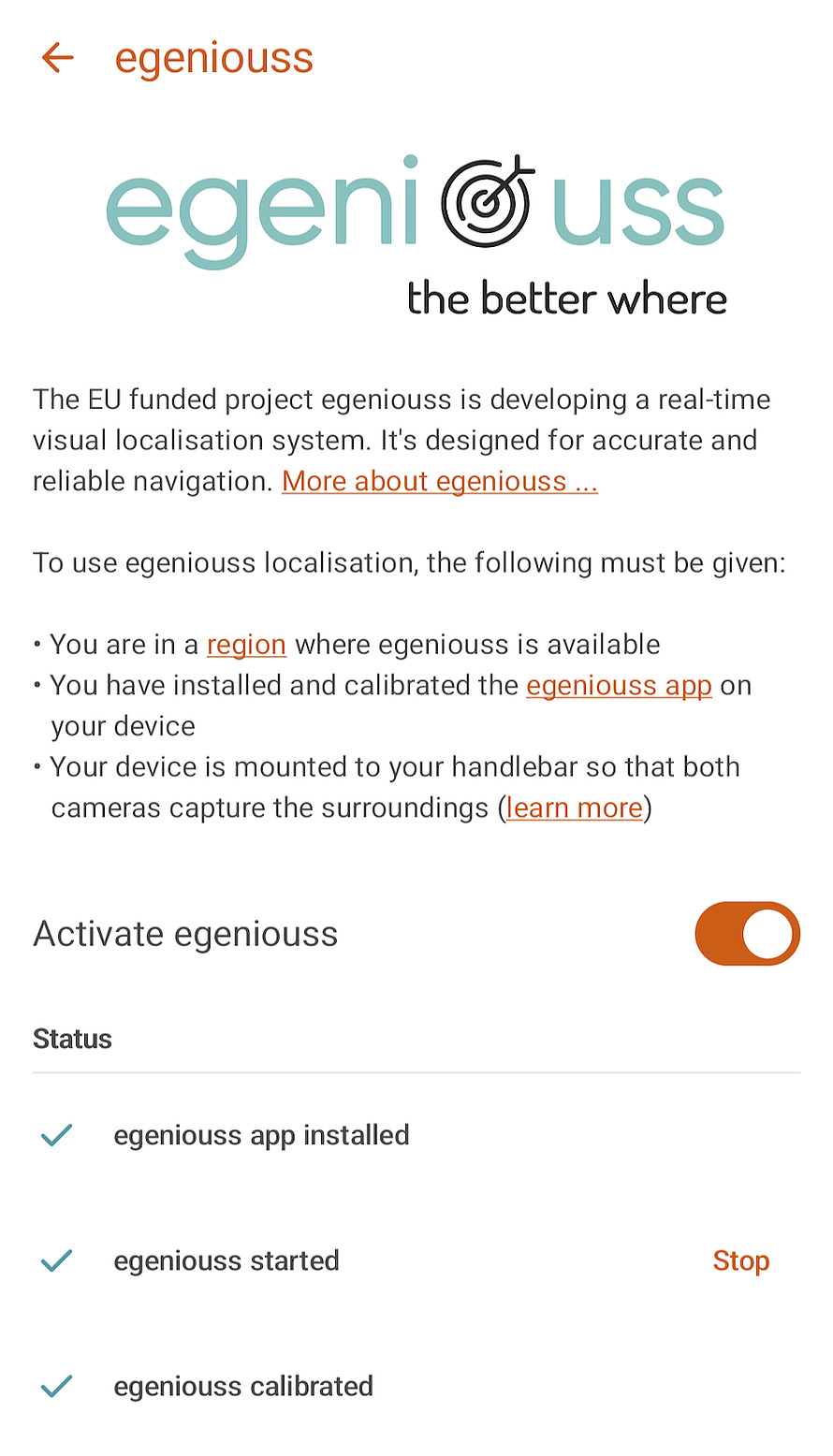
Set up Naviki
Firstly, install the egeniouss app for Android on your smartphone.
Then, in your Naviki app, set egeniouss as your localisation service:
- Tap profile icon top right on Naviki start view
- Tap 'Settings'
- Go to 'Smartbike system'
- Select 'egeniouss'
- Enable switch 'Activate egeniouss'
egeniouss is set to go once you see a green check mark on all three rows under ’Status’.
Attach your mobile to the handlebar
Good camera view for even better positioning

After setting up Naviki, attach your mobile to the handlebar with a standard mount for smartphones.
Make sure that both the front and rear cameras have an unobstructed view of the surroundings.
You can then cycle with egeniouss localisation and use Naviki as usual.
Understand the localisation type
When egeniouss is enabled and you cycle with Naviki's turn-by-turn navigation or you record a trip, you'll find the localisation type in the Naviki cockpit, top right of the map. Swipe to the very right here in order to see the localisation type.

VL

GNSS
egeniouss FAQ
Currently, egeniouss can be tried out in specific test areas set up by the egeniouss project. The egeniouss app and these test areas are not yet available publicly. We will provide information on public test areas as soon as these are available. Please check the egeniouss website for updates.
egeniouss is being developed by a project consortium consisting of Austrian Institute of Technology, Technische Universität Braunschweig, GeoNumerics, Software one, CATUAV, Centro Español de Logística, OpenGis.ch and beemo as the provider of Naviki. The egeniouss project is funded by the European Union Agency for the Space Programme (EUSPA).
In cities, urban canyons interrupt and reflect satellite signals making navigation unrealiable und imprecise. Moreover, satellite signals can be manipulated or blocked. The reliance on satellit based localisation poses safety risks and hinders professional and consumer applications to unfold their full potential. egeniouss changes that by bringing a visual localisation service to the market, reducing dependence on satellite positioning and providing more accuracy in urban areas. egeniouss does this in a cost-effective and democratic manner, as it enables geolocalisation to be handled by local players.
egeniouss uses simplified camera images and compares them with visual data representing urban environments in order to determine your location.
Watch this three-minute explanatory video to get an overview: "Do you know egeniouss? Elevating navigation to the next level"
Learn more on the egeniouss website.
egeniouss uses smartphone cameras to capture images of the surroundings and utilise them for positioning. egeniouss processes these images immediately and simplifies them as much as possible, retaining only the relevant geometric structures. This is necessary to minimise the volume of data in the analysed images, enabling egeniouss to derive geolocation information from numerous images in a very short time. People, or even faces, play no role in this process. As they are considered distracting objects, they are not included in the processing. Images captured by egeniouss do not leave the device on which egeniouss is running and are not stored by egeniouss.
Sure. You can still use Naviki without egeniouss, just as before. Even if you have installed the egeniouss app you can simply disable egeniouss for localisation in the Naviki app settings in order to use GNSS as your localisation type.
More about egeniouss
A future-oriented European approach to localisation
The EU project egeniouss aims to make accurate and reliable navigation available for everyone.
Satellite-based navigation and positioning is the backbone for a multitude of services. But in cities, urban canyons interrupt and reflect satellite signals making navigation unrealiable und imprecise. Additonally, satellite signals can be easily manipulated or blocked.
In an age where positioning has become a truly democratised technology and autonomous systems are in the wings, the overreliance on a single source of geolocalisation poses safety risks and hinders professional and consumer applications to unfold their full potential. egeniouss changes that by bringing a visual localisation service to the market.
The complete story of egeniouss ...